Local Road Routes

LOCAL ROAD ROUTES

Springfield has so much to offer in the way of safe sidewalks and paved trails to run, bike, walk, stroller, or jog on. OMRR helps raise funds for one of the main trail systems in Springfield, the Ozark Greenways. The Frisco Railroad race that OMRR hosts, directly benefits the Greenway Trail System and it is run on the longest rail to trail route in Springfield.

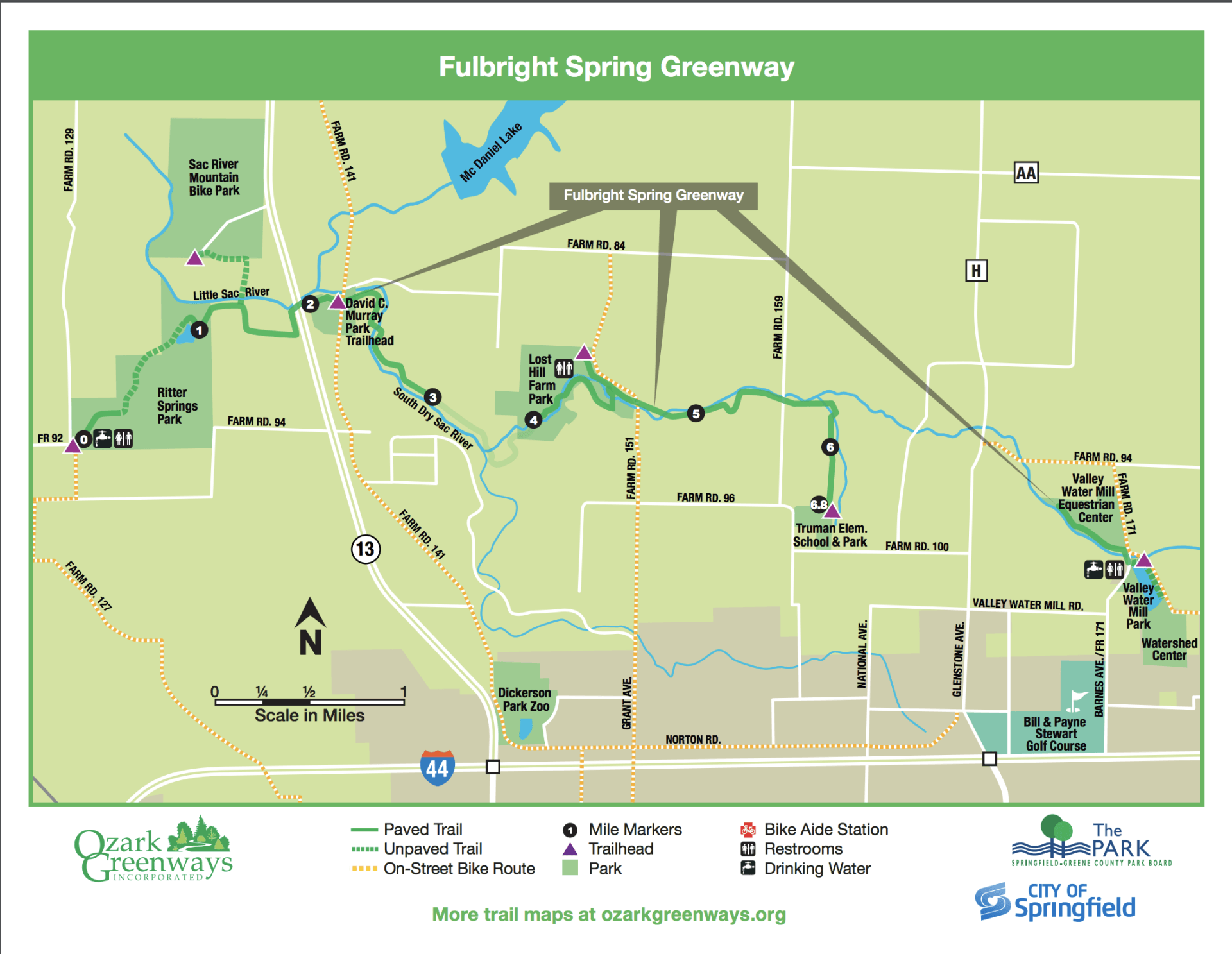
North Springfield Area-

The Fulbright Spring Greenway has three sections that are not yet connected. 


The Ritter Springs trailhead starts at West Stage Coach Dr and heads north on Scott Rd from there you can follow the path eastbound under MO13 until it dead ends. You can also start at Stage Coach head north and continue north into Sac River Trail.


The next Fulbright Spring trailhead is off of North Farm Rd 151 next to a cute old white farmhouse. There are port-a-potties there behind the house. This trail splits east and westbound about a mile after you leave the trailhead. The east-bound trail takes you to Truman Elementary School. The westbound takes you to farmland. Both dead ends.


The final trailhead starts at the Watershed Committee of The Ozarks off East Vally Water Mill Rd. You can meander around the pond and then head northbound for about a 1/4 mile.  


Center Springfield Area-

​The Jordan Creek Greenway has two trails heads that don't connect just yet. The northernmost starting point is at Smith Park behind Evangel University. This trail runs west to the back end of Ozarks Technical Community College. You then hop on John Q Hammons Pky and head south under Chestnut Expy until you see Jordan Valley Park. Head west again until the sidewalk terminates at Jefferson.


The second trail begins at Cruse Park on Grand St west of Kansas Expy. It continues south to Ewing Park and terminates between Bennett St and South Farm Rd 135.


The Fassnight Creek Greenway trailhead starts just west of Phelps Grove Park on Bennett and Jefferson. It continues west and northwest through Fassnight Park and terminates behind the Springfield Skate Park


East Springfield Area-

Known to the locals as Sequiota Trail, the Galloway Creek Greenway, has several routes from many different trailheads. The Pershing School trailhead has no restrooms. The main Sequiota Park entrance has restrooms that are open from dawn to dusk. The James River Greenway trailhead has no restrooms either. From this trail, you can access the Trail of Honor and The Nature Center.


South & West Springfield Area-

The South Creek Greenway also has several trailheads to start your journey on. McDaniel Park has no restrooms and is the easternmost start of this trail system.  Nathanael Greene/Close Memorial Park (Botanical Gardens), has restrooms open from dawn until dusk. Tal's Trailhead (Wilson's Creek Greenway), also has no restrooms and connects you either south towards Wilson's Creek or North toward Rutledge-Wilson Farm.


The Ward Branch Greenway is two separate trails that will eventually be connected. The first trailhead starts on National and Bradford Parkway. There is a cute little lake with geese that can start out an adventure. This trail heads southbound past the hospital and toward Campbell. It has a couple of tunnels that will flood during the rainy season.


The second trailhead starts at Wanda Gray Elementary School and heads south on a sidewalk under Farm Road 186. This will end right behind the Missouri Institute of Natural Science's (Riverbluff Cave Museum)

Share by: